Spatial-temporal Assessment and Mapping of the Air Quality and Noise Pollution in a Sub-area Local Environment inside the Center of a Latin American Megacity: Universidad Nacional de Colombia - Bogotá Campus
Copyright ⓒ 2018 by Asian Journal of Atmospheric Environment
This is an open-access article distributed under the terms of the Creative Commons Attribution Non-Commercial License (http://creativecommons.org/licenses/by-nc/4.0/), which permits unrestricted non-commercial use, distribution, and reproduction in any medium, provided the original work is properly cited.
Abstract
The construction, development and maintenance of an economically, environmentally and socially sustainable campus involves the integration of measuring tools and technical information that invites and encourages the community to know the actual state to generate positive actions for reducing the negative impacts over the local environment. At the Universidad Nacional de Colombia - Campus Bogotá, a public area with daily traffic of more than 25000 people, the Environmental Management Bureau has committed with the monitoring of the noise pollution and air quality, as support to the campaigns aiming to reduce the pollutant emissions associated to the student’s activities and campus operation. The target of this study is based in the implementation of mobile air quality and sonometry monitoring equipment, the mapping of the actual air quality and noise pollution inside the university campus as a novel methodology for a sub-area inside a megacity. This results and mapping are proposed as planning tool for the institution administrative sections. A mobile Kunak Air & OPC air monitoring station with the capability to measure particulate matter PM10, PM2.5, Ozone (O3), Sulfur Oxide (SO2), Carbon Monoxide (CO) and Nitrogen Oxide (NO2) as well as Temperature, Relative Humidity and Latitude and Longitude coordinates for the data georeferenciation; and a sonometer Cirrus 162B Class 2 were used to perform the measurements. The measurements took place in conditions of academic activity and without it, with the aim of identify the impacts generated by the campus operation. Using the free code geographical information software QGIS 2.18, the maps of each variable measured were developed, and the impacts generated by the operation of the campus were identified qualitative and quantitively. For the measured variables, an increase of around 21% for the LAeq noise level and around 80% to 90% for air pollution were detected during the operation period.
Keywords:
Air quality, Environmental Impact, Geographical Information System GIS, Monitoring systems, Noise pollution1. INTRODUCTION
The problematic of air pollution at the city of Bogotá, Colombia, is an issue that has been widely researched and studied by local and international scientific community (Bossche et al., 2015). Particularly, the problem with air pollution in the city is associated to the economical growing during the last years, the only control of the pollutants has been done by the local monitoring network which began its operation in the year 1997, however studies have shown that observation may not be enough to identify the negative impacts and affectation to the specific communities and population at the local and micro scale (Larson et al., 2017).
Particulate matter pollution is a public health issue and has repercussion upon the population. Exposure to particulate matter has negative effects in human health (Zamora et al., 2015), affecting their productivity and social activity. High levels of particulate matter are related to cardiovascular diseases, asthma and lung cancer (Gozzi et al., 2015). Air quality is a problem related with many aspects such as atmospheric phenomena, horizontal transport, meteorology and mobile and fixed pollution sources that converge in a complex system of interactions and micro environments within the city (Adams and Kanaroglou, 2016; Behera et al., 2015). Furthermore, noise pollution has also negative impacts upon human health causing mental disorders, stress, loss of audition and reduce productivity (Guevara and Guevara, 2018; Silva and Mendes, 2012; Stansfeld and Matheson, 2003). The aspects mentioned above finally affects the city economy due to the public health affectations (Nedbor-gross et al., 2017).
Air quality detriment is a concern due to the lack of control, complexity of the sources and insufficient monitoring systems and procedures. An internal policy for environmental management at the Universidad Nacional de Colombia Bogotá Campus considers aspects from the operation; among them, it is considered the energy efficiency, water consumption, waste management, noise pollution and air quality, taking into account that the area is used daily by more than 25000 people. The aim of the environmental policies and procedures that are being implemented in the university aims to offer a healthy environment for the development of the academic activities, and to make the campus a sustainable institution using efficient strategies and technologies to reduce negative impacts that are generated by the operation of the campus.
During the last years, air quality monitoring techniques were developed following the needs and knowledge acquired from air pollution, allowing the analysis of datasets coming from fixed monitoring stations distributed strategically around the city ( Jensen et al., 2017; Liu et al., 2017). Moreover, fixed monitoring is not enough to measure the air quality in great urban areas due to the local sources, topography and weather conditions that affect the chemical composition and concentration of pollutants at local and micro scale. For mapping and local studies, fixed air quality monitoring stations are a drawback for resolution. A feasible alternative to control the air quality at a local and micro scale level, are the mobile monitoring with specialized equipment (Elbir et al., 2010). The objective of this study is based in the implementation of mobile air quality and sonometry monitoring equipment, the mapping of the actual air quality and noise pollution inside the university campus was carried out. This results and mapping are proposed as planning tool for the institution administrative sections.
A variety of mobile devices with integrated sensors, different technologies and platforms count with capability of measure in real time the spatial and temporal variation of the air quality. Spanish company Kunak® counts with mobile devices specialized in measurements for particulate matter OPC (Optical Particle Counter) and pollutant gases such as Nitrous Oxide, Sulfur Oxide, Carbon Monoxide and Ozone. Advantages of this devices are mobility, low costs, low weight and real time data transmission (Righini et al., 2014). Coupled with the mobile air quality monitoring, measurements of the noise levels with mobile devices and sonometers allow to keep control of the noise tension levels and exposure at a local scale through development of local noise levels mapping in open air environments and streets (Ramírez and Domínguez, 2013; Augusto and Castro, 2009).
2. MATERIALS AND METHODOLOGY
2. 1 Materials
Control programs have been planned before for the period between 2016 and 2018, the development and implementation of strategies that make the academic area in the city center of Bogotá is a short time target aiming to a sustainable environment and environmentally friendly operation of the elements inside the whole system. Equipment for the monitoring of the air quality and sonometry: The air quality station is a Kunak® Air&OPC mobile equipment which have the capability of measure different sizes of particulate matter PM10, PM2.5, with the resolution of ±0.001 μg/m3, the sensor for particles is an Optical Particle Counter which works by the same conventional principle of detecting the scattered light from individual particles carried in a sample air stream with a laser beam. The equipment also has the sensors for measure four pollutant gases: Ozone (O3), Sulfur Oxide (SO2), Carbon Monoxide (CO) and Nitrogen Oxide (NO2) with the resolution of ±0.1 ppb (Data, 2015; Opc, 2015).
Kunak® Air&OPC counts with a built-in GPS and GPS+GLONASS receivers. This allows the Kunak® to register the coordinates of latitude, longitude and altitude, at the same time with the air sampling, in order to georeferenciate the data obtained for pos-processing and development of maps with GIS software. Temperature and Humidity are also measured with sensors in the equipment (Opc, 2015).
Measurements of noise levels were performed with a sonometer brand Cirrus® 162B class 2 with a microphone MK:216 pre-polarized and a removable preamplifier MV:200, which provides the information of sound level in real time and has a sensibility of ±0.01 dB with a range between the 20 and 140 dB (Red, 2014).
2. 2 Measurements
The characterization of the air quality and noise pollution in area of study requires a methodology that fits the specific needs mentioned above, physical characteristics and topography of the campus. Various methodologies were analyzed and adapted (SDA, 2010b; MAVDT, 2006). Street characterization and background strategies of measurements were adapted to define a more suitable methodology for the academic area which considers the inner roads, pedestrian’s platforms, parking lots, green areas and squares (Larson et al., 2017; Righini et al., 2014; Ambiente et al., 2010; Henrique et al., 2002).
Using the mobile characteristic of the used devices to measure and the capability to obtain the GPS information in real time, a mobile monitoring strategy was developed, the aim was to get the information of the outside areas of the university campus, excluding the interior of the buildings, so that the data collected during the measure campaigns could be processed with a GIS software later. Trajectories were designed and classified into three different areas (Fig. 2), the outside roads, inner main roads and pedestrian platforms and green areas inside the university campus to cover most of the terrain, in the map, numbers from 1 to 7 represent the approximate location of important sources inside the campus:
- 1. Transport Vehicles parking and service and maintenance machinery deposit (open air)
- 2. Food Institute Lab Boiler (40 BHP)
- 3. Chemical Engineering Lab Boiler (50 BHP)
- 4. Mechanical Engineering Lab Boiler (20 BHP)
- 5. Biotechnology Institute Lab Boiler (15 BHP)
- 6. Principal Place and Central Restaurant (high activity point)
- 7. Chemical Department Labs (Toxic gases extractors)
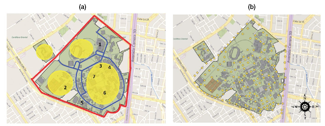
(a) Different areas for the data recollection, in red the external roads, in blue the inner roads and in yellow the pedestrian zones. (b) Trajectory points taken for mapping.
The trajectories were made with various travels during a two-month period, one for vacations period and one for normal operation of the campus. Four travels for each condition were made to obtain a representative dataset of the measured variables. Measurements were done between 9 am and 2 pm, this hours were selected due to the high traffic of persons inside the campus arriving at classes, moving from one building to another and also including the lunch hour that corresponds to a peak in activity of the community. Each measure took about 2 to 3 hours to be completed, with the equipment carried by hand and backpack, the battery and main board for the Kunak® Air&OPC device and the sonometer Cirrus® 162B were carried inside the backpack, meanwhile the Kunak® Air&OPC device was carried by hand at 1.70 meters above the ground level, which corresponds approximately at the height of a person head (Meisel and Vega, 2004). Walking was the transport mean chosen for making the measures because most of the community (Table 1) makes their travels inside the campus by foot. Data from Table 1 was obtained by observation and quantification of the transport users inside the university campus during the measurement period.
2. 3 Data Processing
Data obtained from the measurements made as shown in Figs. 3 to 9 were datasets of time stamp, sample flow rate, pollutant concentration, for Ozone (O3), Sulfur Oxide (SO2), Carbon Monoxide (CO) and Nitrogen Oxide (NO2), noise level, latitude, longitude, altitude, temperature and relative humidity. This data was processed with a python 3.5 program to separate data and obtain a comma separated values (.csv) file that can be charged and processed in GIS software.
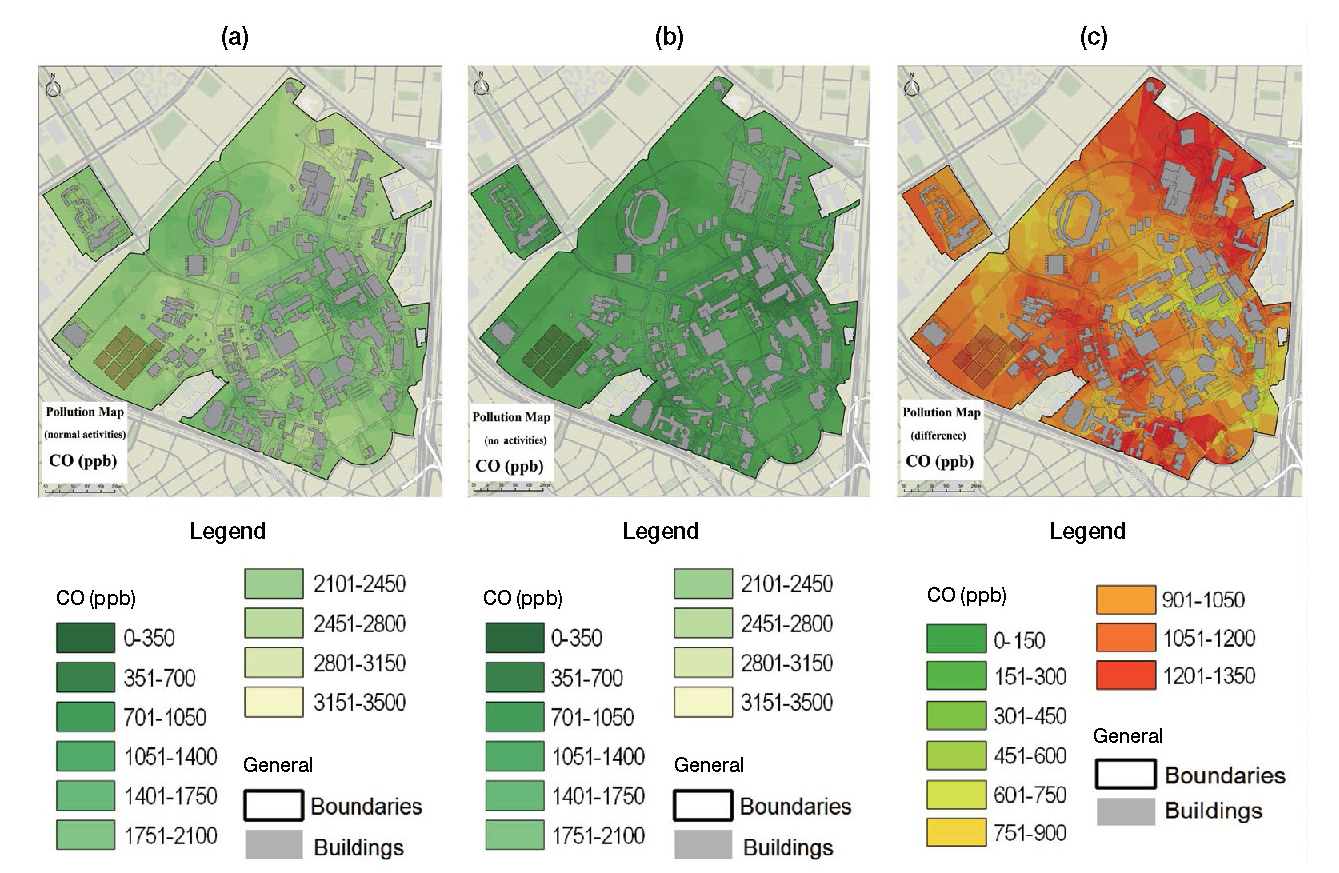
(a) Map for Carbon Monoxide CO levels during normal operation period. (b) Map for Carbon Monoxide CO levels during vacation period. (c) Map of the difference between both conditions considered for Carbon Monoxide.
To process the data, the free code software QGis® 2.18 is used. This software has the advantages of having a simple graphic interface and the capacity to process layers of vectorial data, raster data and obtain geographical data from web databases such as Google MapsTM and BingMapsTM. The coordinates system defined to the Bogotá, Colombia zone, MAGNA-SIRGAS, was used to georeferenciate all the data and layers of the maps.
Once the data was charged into the GIS software, an interpolation with the method of Kigring (Hengl, 2007) was made between the data to obtain the values all around the campus surface, this process was made for both conditions considered, vacations period and normal operation, and for each one of the variables measured of air quality and noise level; obtaining 14 maps Fig. 3, two for each variable measured (Liu et al., 2017; Wang et al., 2015; Righini et al., 2014; Merbitz et al., 2012).
Kigring interpolation is an advanced geostatistical procedure that generates an estimated surface from a scattered set of points with z-values. In contrast with other interpolation methods as Inverse Distance Weighted (IDW), referred normally as deterministic methods because of the use of specified mathematical formulas, the Kigring interpolation includes the statistical relationship between among the measured points.
Therefore, geostatistical methods like Kigring is capable of producing a prediction surface and also provide a degree of certainty or accuracy of the predictions (Athan et al., 2016).
Kriging assumes that the distance or direction between sample points reflects a spatial correlation that can be used to explain variation in the surface. The Kriging tool fits a mathematical function to a specified number of points, or all points within a specified radius, to determine the output value for each location. Kriging is adequate when it is known that there exists a spatially correlated distance or directional bias in the data. It is often used in soil science and geology (Athan et al., 2016).
3. RESULTS AND DISCUSSION
3. 1 Air Quality Analysis
The analysis of the data and processing lead to the identification of pollutant levels in the university campus. Pollutants studied were O3, CO, NO2, SO2, PM2.5 and PM10. Levels of pollutant were detected to be lower during inactivity period, with a level of increase for each pollutant (Table 2).

Concentration levels and statistical parameters for each studied pollutant in the two conditions considered in the study.
Levels shown in Table 2 are below the level stablished in the normativity by the local authorities (MAVDT, 2010), limits for pollutants are for CO-10000 ppb, O3-80 ppb, NO2-100 ppb, SO2-80 ppb, PM2.5-25 μg/m3, PM10-50 μg/m3, however, there are episodes which are above the recommended level that could be related to specific causes and spontaneous sources of emissions, different causes such as dust re-suspension, vehicle emissions, machinery operation, grass cutting, boilers in operation in labs, horizontal transport from external factors (Adams and Kanaroglou, 2016; Bossche et al., 2015), among others. For identification of the possible causes of the concentration of pollutants and characterization of the main factors affecting the local air quality at the university, a receptor model as Positive Matrix Factorization (PMF) or Chemical Mass Balance (CMB) could evidence a first approximation to the main sources of emission (Nedbor-gross et al., 2017).
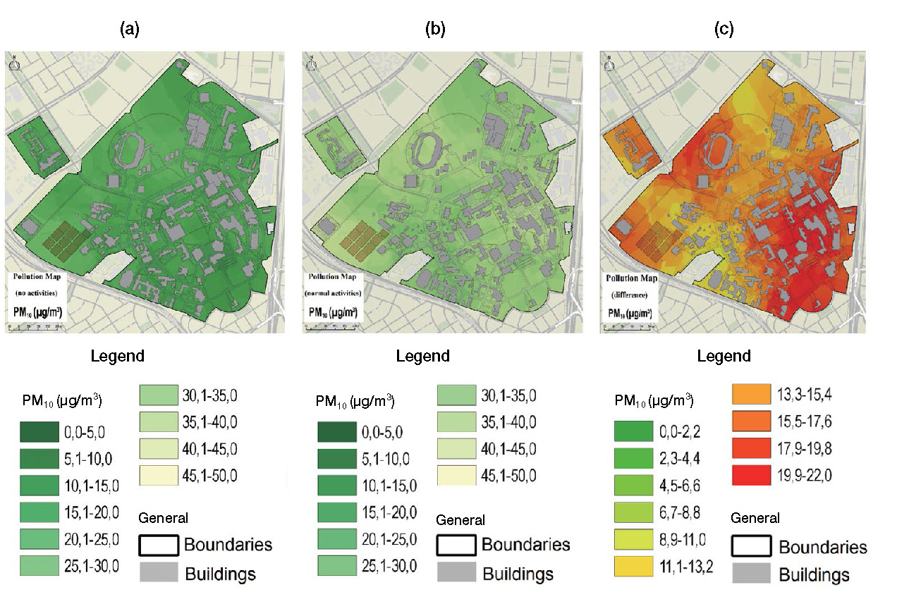
From the maps developed in QGis®, Figs. 3c, 4c, 5c, 6c, 7c and 8c, show the difference between both conditions, in red color are the areas where more impact was generated, and in yellow areas the minor difference between vacation and operation period was detected, this allows a better analysis and clearer results.
Maps obtained from the interpolation process in QGis® software are shown in Fig. 3, for each contaminant the concentration levels during the period of vacations and during operation period are contrasted. Observation of the maps can provide information about the areas inside the campus that are affected by higher levels of pollution, mainly in the boundaries of the campus where main roads such as the Avenida el Dorado highway and the NQS avenue are located (Mura et al., 2017; Istrate et al., 2014; Puliafito et al., 2003).
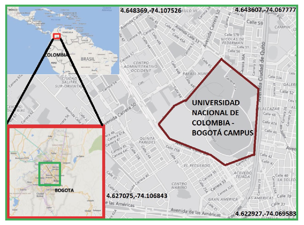
University campus, due to its geo location in the city (Fig. 1), suffers the negative effects from the city activity, industrial areas like Puente Aranda are located relatively near the university (Gromke et al., 2008; Vardoulakis et al., 2003). Transportation from other pollution sources is driven by meteorological conditions, the effect of wind direction and wind speed, thermal inversion and mixture height are also aspects that should be considered for further studies (Sportisse, 2007).
From the observation of the levels of Nitrogen Oxide NO2 (Fig. 4), a pollutant associated generally with the internal combustion engines for the vehicles, higher levels were detected in the areas surrounding the inners roads of the campus and areas near the main externalarterial roads where heavy traffic is permanent. Levels of NOx are also related to the concentration of the Ozone (Fig. 5), which as a secondary pollutant, is produced from the interaction with solar radiation. As measures were made in hours between 9 am to 2 pm, radiation was at its highest levels, ozone concentrations were detected to be high around the areas with high NO2 concentration.
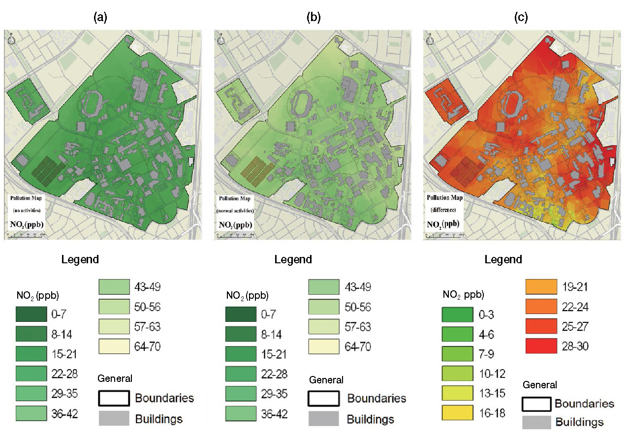
(a) Nitrogen Oxide NO2 levels during normal operation period. (b) Nitrogen Oxide NO2 levels during vacation period. (c) Map of the difference between both conditions considered for Nitrogen Oxide.
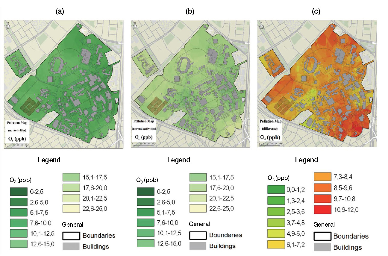
(a) Ozone O3 levels during normal operation period. (b) Ozone O3 levels during vacation period. (c) Map of the difference between both conditions considered for Ozone.
For the particulate matter levels of PM10 and PM2.5 (Figs. 7 and 8), observations show that, as for Nitrogen Oxide, the concentrations could be associated mainly to mobile sources inside the university campus. However, high levels are also detected in main places and near restaurants of the campus, where fuels as coal or propane are burn for the preparation of meals and aliments. Some of this public food establishments are illegally installed inside the university and affect the air quality as well. Furthermore, the Sulfur Oxide levels (Fig. 6) are associated to diesel burn in the operation of machinery for maintenance, inner transport buses and boilers; this sources are of periodical operation and must be controlled with preventive and corrective maintenance. In the NQS avenue the traffic of heavy vehicles as buses, trucks and massive transport buses could be cause for the concentration levels of SO2 inside the university campus (Istrate et al., 2014; Darido and Cain, 2007).
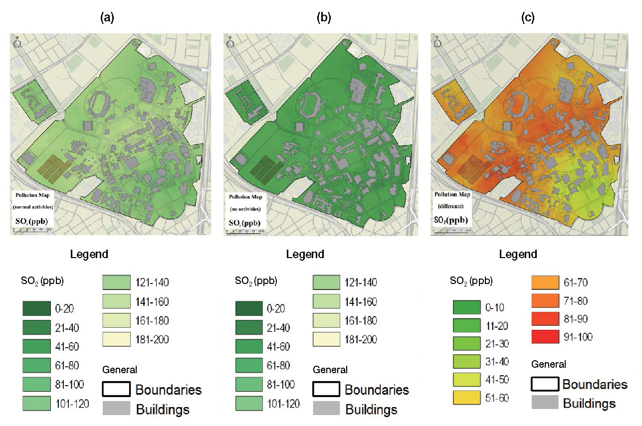
(a) Sulfur Oxide SO2 levels during normal operation period. (b) Sulfur Oxide SO2 levels during vacation period. (c) Map of the difference between both conditions considered for Sulfur Oxide.
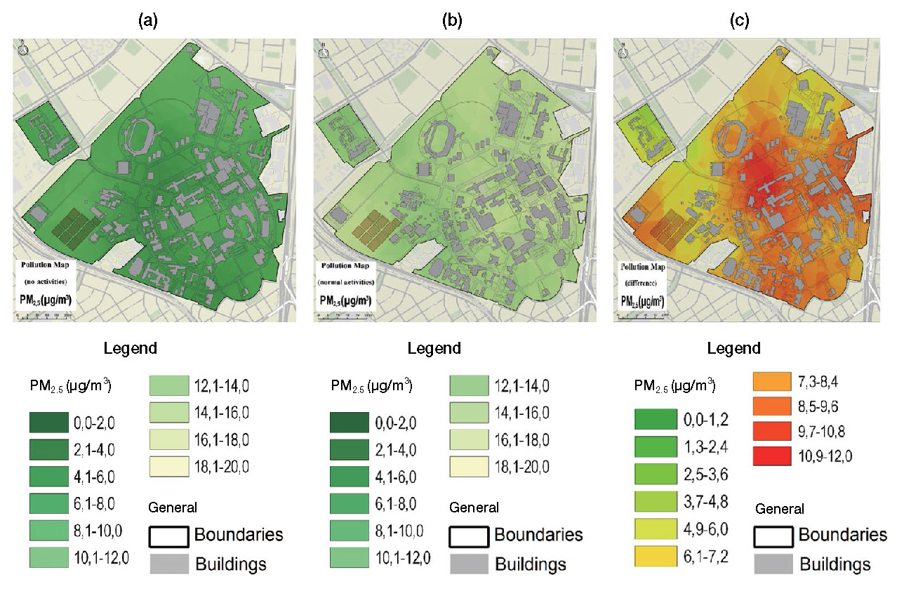
(a) PM2.5 levels during normal operation period (b) PM2.5 levels during vacation period (c) Map of the difference between both conditions considered for PM2.5 .
3. 2 Noise Pollution Analysis
According to the measures made for the noise levels inside the campus shown in the Table 3, it was determined that during operation period, the decibels that are present in the university are normally below the recommended levels by the normativity stablished by the local authority (MAVDT, 2010; SDA, 2010), this is below LAeq 65 dB (A), nevertheless, in the boundaries of the university with arterial roads, noise levels reach up to values between 70 dB (A) and 80 dB (A). The pain threshold is stablished around 110 dB, levels of noise detected around this limit correspond to spontaneous increase in the tension level caused by vehicle horns, machinery or industrial equipment and amplification equipment, however this increases are of low exposure time, lower than 2 minutes, and do not represent a threat for the community.
The increase of the noise levels detected between vacation period and normal operation of the university are represented in Fig. 9, the impact generated by the activities is mostly located in the main buildings where most of the classes and academic activities are carried out by the community, with levels of 45 dB (A) to 68 dB (A), in contrast, the gardens and open air areas, are kept with the lowest levels of noise, around 35 dB (A) to 50 dB (A). It is important to recall that in this study it was only considered noise levels outside of the buildings (Eduardo et al., 2015; Ramírez and Domínguez, 2013; Hunashal and Patil, 2012; Ortega, 2012; Augusto and Castro, 2009). Noise level maps were made according to the guidelines stablished in the local normativity (MAVDT, 2006).
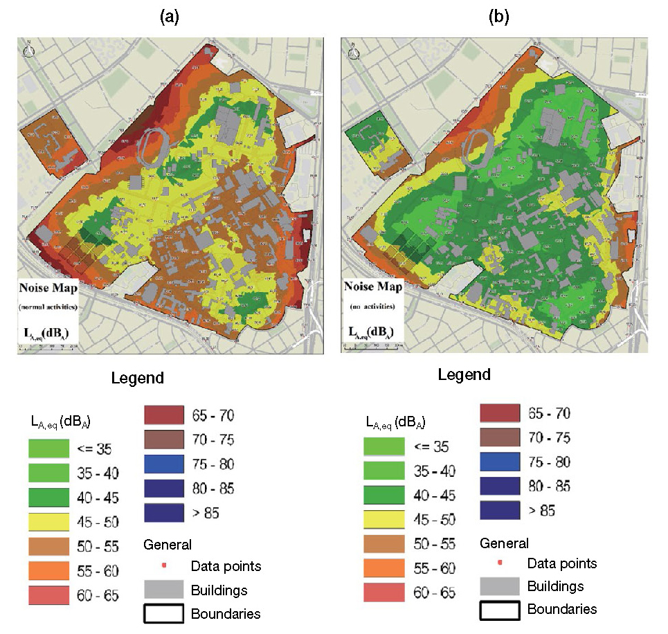
Noise level maps of the university campus (a) during normal operation period, (b) during vacation period.
The World Health Organization (WHO) indicates that a healthy noise level would be below 55 dB (A) (Jensen et al., 2017; BarrigÓn Morillas et al., 2002), considering that the university community is composed by approximately 50000 people that stay inside the campus for more than 2 hours at least, and 25000 during more than 8 hours daily, exposure to high levels of noise can cause they illness and problems associated with noise pollution, increasing the risk of panic attacks, stress, and other mental and physical pathologies, that reduce their performance in daily activities (Ramírez and Domínguez, 2013; Pathak et al., 2008).
4. CONCLUSIONS
The spatial analysis of the air quality at the campus of the Universidad Nacional de Colombia in the city of Bogotá provided information about the concentration for some of the pollutants most studied worldwide, such as Nitrogen Oxide NO2, Sulfur Oxide SO2, Ozone O3, Carbon Monoxide CO and particulate matter PM10 and PM2.5. The methodology presented in this paper resulted in a valuable tool for an approximation of the spatial representativeness of the air quality and noise pollution inside the campus micro-environment. Concentrations of pollution levels in the air show that the normal operation of the campus represents a negative impact for the environment and that new internal policies and control of the sources could help addressing air quality issues. Through further studies and deeper analysis, particular sources that affect air quality can be identified, future studies can provide meaningful information about this sources, nevertheless, it is observed that main issues come from mobile emission sources from inside the campus and from the arterial and main roads in the surroundings, heavy vehicles and passenger transportation vehicles from the massive transport system Transmilenio and Urban buses, are an important pollutant source that need to be controlled.
Main advantage of the approach of this study is the availability for obtaining local data at microscale, considering a wide spatial and temporal coverage because of the use of specialized mobile equipment and resources such as the Kunak® Air&OPC and sonometer Cirrus 162B used in this study. The processing and calculation time of the information obtained was relatively fast and give an overview of the spatial variations and distribution of the air quality and noise pollution inside the campus. The Kigring interpolation method resulted in an effective approach for spatial evaluation, providing a degree of certainty in the predictions for the interpolated surface values.
The increase in the pollutants sensed was identified, the impact generated by the community activities during normal operation period represent a negative effect upon the environment, as shown in Table 2, the increase for each pollutant was around 80% and 90%, for O3 was 81.99%, for CO was 84.82%, for NO2 was 81.30%, for SO2 was 81.77%, for PM2.5 was 86.51% and for PM10 was 83.93%, as for the noise, an increase of 21.36% was detected.
Results show that in macro-regional domains, the evaluation for air quality state should consider activity in the neighbor urban areas, emissions generated at industrial zones of the city and meteorological variables, for providing a more accurate assessment. Numerical modeling and computational simulation represent a complementary tool that can provide valuable information about the variability in temporal and spatial domain, this tools can be applied for further studies in the micro and macro scale.
References
-
Adams, M.D., Kanaroglou, P.S., (2016), Mapping real-time air pollution health risk for environmental management: Combining mobile and stationary air pollution monitoring with neural network models, Journal of Environmental Management, 168, p133-141.
[https://doi.org/10.1016/j.jenvman.2015.12.012]

- Ambiente, M.D.E., Territorial, V.Y.D., Para, P., Monitoreo, E.L., La, Y.S.D.E., Aire, C.D.E.L., (2010), Manual de diseño de sistemas de vigilancia de la calidad del aire ©, p1-135.
- Athan, T., Ersts, P., Macho, W., Engel, C., Junek, L., Sutton, T., Emde, A., Blazek, R., Ghisla, A., Farmer, C., Morely, B., Jansen, D., Bruy, A., Jacolin, Y., Contreras, G., Holl, S., Mitchell, T., Willis, D., Corti, P., Nijssen, R., Neto, A., Otto Dassau, O., Horning, N., Koy, K., Fischer, J., Macaulay, G., Duivenvoorde, R., Schmid, A., Dobias, M., Homann, M., Luthman, L., Hugentobler, M., Sherman, G., Neumann, A., Tran-Quang, H., (2016), QGIS User Guide, instalation and programation.
- Augusto, F., Castro, D.N., (2009), Noise mapping of densely populated neighborhoods - example of Copacabana, Rio de Janeiro -, Brazil. Environ Monit Assess, p309-318.
-
Barrigón Morillas, J.M., Gómez Escobar, V., Méndez Sierra, J.A., Vílchez Gómez, R., Trujillo Carmona, J., (2002), An environmental noise study in the city of Cáceres, Spain, Applied Acoustics, 63, p1061-1070.
[https://doi.org/10.1016/s0003-682x(02)00030-0]

- Behera, S.N., Sharma, M., Mishra, P.K., Nayak, P., Damez-fontaine, B., Tahon, R., (2015), Urban Climate Passive measurement of NO2 and application of GIS to generate spatiallydistributed air monitoring network in urban environment, URBAN CLIMATE, (2).
- Bossche, J. , Van Den, Peters, J., Verwaeren, J., Botteldooren, D., Baets, B. De., (2015), Mobile monitoring for mapping spatial variation in urban air quality: development and validation of a methodology based on an extensive dataset, Atmospheric Environment, 105, p148-161.
- Darido, G., Cain, A., (2007), Report on South American Bus Rapid Transit Field Visits: Tracking the Evolution of the TransMilenio Model, (December), p1-40.
- Data, G., (2015), Wireless Air Quality Monitor-KUNAK® AIR K-A10, ((August)), p1-8.
- Eduardo, P., Fiedler, K., Henrique, P., Zannin, T., (2015), Evaluation of noise pollution in urban traffic hubs - Noise maps and measurements, Environmental Impact Assessment Review, 51, p1-9.
-
Elbir, T., Mangir, N., Kara, M., Simsir, S., Eren, T., Ozdemir, S., (2010), Development of a GIS-based decision support system for urban air quality management in the city of Istanbul, Atmospheric Environment, 44(4), p441-454.
[https://doi.org/10.1016/j.atmosenv.2009.11.008]

-
Gozzi, F., Della, G., Marcelli, A., (2015), Mobile monitoring of particulate matter: State of art and perspectives, Atmospheric Pollution Research, 7(2), p228-234.
[https://doi.org/10.1016/j.apr.2015.09.007]

-
Gromke, C., Buccolieri, R., Di Sabatino, S., Ruck, B., (2008), Dispersion study in a street canyon with tree planting by means of wind tunnel and numerical investigations - Evaluation of CFD data with experimental data, Atmospheric Environment, 42, p8640-8650.
[https://doi.org/10.1016/j.atmosenv.2008.08.019]

-
Guevara, M., Guevara, F., (2018), An environmental noise study in the industrial, commercial, residential areas and arterial roads in western Bogotá, Colombia, Revista de Investigación Agraria y Ambiental, 9.
[https://doi.org/10.22490/21456453.2055]

- Hengl, T., (2007), Revista de Investigación Agraria y Ambiental, I. for E. Sustainability Ed, (First Edit) Ispra, Italy, Joint Research Centre European Commission.
- Henrique, P., Zannin, T., Belisa, F., (2002), Environmental noise pollution in the city of Curitiba, Brazil, Applied Acoustics, 63, p351-358.
-
Hunashal, R.B., Patil, Y.B., (2012), Assessment of Noise Pollution Indices in the City of Kolhapur, India, Procedia - Social and Behavioral Sciences, 37, p448-457.
[https://doi.org/10.1016/j.sbspro.2012.03.310]

- Istrate, I.A., Oprea, T., Rada, E.C., Torretta, V., (2014), Noise and air pollution from urban traffic, The Sustainable City, 191, p1381-1389.
-
Jensen, S.S., Ketzel, M., Becker, T., Christensen, J., Brandt, J., Plejdrup, M., Winther, M., Nielsen, O.-K., Hertel, O., Ellermann, T., (2017), High resolution multi-scale air quality modelling for all streets in Denmark, Transportation Research Part D, 52(2), p322-339.
[https://doi.org/10.1016/j.trd.2017.02.019]

-
Larson, T., Gould, T., Riley, E.A., Austin, E., Fintzi, J., Sheppard, L., Yost, M., Simpson, C., (2017), Ambient air quality measurements from a continuously moving mobile platform: Estimation of area-wide, fuel-based, mobile source emission factors using absolute principal component scores, Atmospheric Environment, 152, p201-211.
[https://doi.org/10.1016/j.atmosenv.2016.12.037]

- Liu, Z., Xie, M., Tian, K., Gao, P., (2017), GIS-based analysis of population exposure to PM2.5 air pollution - A case study of Beijing, Journal of Environmental Sciences, 59, p48-53.
- MAVDT, M., de A. V. y, D. T., Resolucion 0627 De 2006 Norma nacional de emisión de ruido, Bogotá, Secretaría General de la Alcaldía Mayor de Bogotá D.C.
- MAVDT, M., de A. V. y, D. T., (2010), Resolucion 0610 de 2010, Retrieved October 16, 2017, from http://www.alcaldiabogota.gov.co/sisjur/normas/Norma1.jsp?i=39330.
- Meisel, A., Vega, M., (2004), A tropical success story: A century of improvements in the biological standard of living, Colombia 1910-2002, Venice, Italy.
-
Merbitz, H., Buttstädt, M., Michael, S., Dott, W., Schneider, C., (2012), GIS-based identification of spatial variables enhancing heat and poor air quality in urban areas, Applied Geography, 33, p94-106.
[https://doi.org/10.1016/j.apgeog.2011.06.008]

- Nedbor-gross, R., Henderson, B.H., Pérez-Peña, M.P., Pach, J.E., (2017), Air Quality modeling in Bogotá, Colombia using local emissions and Air quality modeling in Bogot a natural mitigation factor adjustment for re-suspended particulate matter, Atmospheric Pollution Research, (2002), p1-10.
- Opc, K., (2015), Kunak K-P10 Datasheet, Pamplona, Spain, Kunak Sensing Anywhere.
- Ortega, C.P., (2012), Chapter 2 : Effects of noise pollution on birds : A brief review of our knowledge, (Efectos de la Polución Sonora en Aves : una Breve Revisión de Nuestro Conocimiento) Author(s): Catherine P. Ortega Reviewed work(s): CHAPTER 2 effects of noise POL.
-
Pathak, V., Tripathi, B.D., Mishra, V.K., (2008), Evaluation of traffic noise pollution and attitudes of exposed individuals in working place, Atmospheric Environment, 42(16), p3892-3898.
[https://doi.org/10.1016/j.atmosenv.2007.12.070]

-
Puliafito, E., Guevara, M., Puliafito, C., (2003), Characterization of urban air quality using GIS as a management system, Environmental Pollution, 122, p105-117.
[https://doi.org/10.1016/s0269-7491(02)00278-6]

-
Ramírez, A., Domínguez, E., (2013), Modeling urban traffic noise with stochastic and deterministic traffic models, Applied Acoustics, 74, p614-621.
[https://doi.org/10.1016/j.apacoust.2012.08.001]

-
Ramírez, O., Mura, I., Franco, J.F., (2017), How Do People Understand Urban Air Pollution? Exploring Citizens' Perception on Air Quality,Its Causes and Impacts in Colombian Cities, Open Journal of Air Pollution, 6(1), p1-17.
[https://doi.org/10.4236/ojap.2017.61001]

- Red, O., (2014), Manual del Usuario Sonómetro Optimus Red (CR : 162B), Sociedad Acustical S.A.
-
Righini, G., Cappelletti, A., Ciucci, A., Cremona, G., Piersanti, A., Vitali, L., Ciancarella, L., (2014), GIS based assessment of the spatial representativeness of air quality monitoring stations using pollutant emissions data, Atmospheric Environment, 97, p121-129.
[https://doi.org/10.1016/j.atmosenv.2014.08.015]

- SDA, (2010a), Resolución 6919 de 2010 Plan Local de Recuperación Auditiva, para mejorar las condiciones de calidad sonora en el Distrito Capital, Bogotá, Secretaría General de la Alcaldía Mayor de Bogotá D.C.
- SDA, S. D. de A, (2010b), Resolución 6918 de 2010. Bogotá, Colombia, Secretaría Distrital de Medio Ambiente.
-
Silva, L.T., Mendes, J.F.G., (2012), City Noise-Air: An environmental quality index for cities, Sustainable Cities and Society, 4, p1-11.
[https://doi.org/10.1016/j.scs.2012.03.001]

- Sportisse, B., (2007), Pollution atmosphérique. Des processus à la modélisation, 1st ed, Paris, France, Springer.
- Stansfeld, S.A., Matheson, M.P., (2003), Noise pollution: Nonauditory effects on health, British Medical Bulletin, 68, p243-257.
-
Vardoulakis, S., Fisher, B.E.A., Pericleous, K., Gonzalez-Flesca, N., (2003), Modelling air quality in street canyons: A review, Atmospheric Environment, 37(2), p155-182.
[https://doi.org/10.1016/s1352-2310(02)00857-9]

-
Wang, H., Zhu, Y., Jang, C., Lin, C., Wang, S., Fu, J.S., Gao, J., Deng, S., Xie, J., Ding, D., Qiu, X., Long, S., (2015), Design and demonstration of a next-generation air quality attainment assessment system for PM2.5 and O3, JES, 29, p178-188.
[https://doi.org/10.1016/j.jes.2014.08.023]

- Zamora, A.G., Borda, P., Mayorga, C., (2015), Boletín enfermedad respiratoria aguda ERA I Trimestre 2015 Boletín Enfermedad respiratoria aguda ERA.
