Satellite Based Interpretation of Stability Parameters on Convective Systems over India and Srilanka
Copyright © 2020 by Asian Association for Atmospheric Environment
This is an open-access article distributed under the terms of the Creative Commons Attribution Non-Commercial License (http://creativecommons.org/licenses/by-nc/4.0/), which permits unrestricted non-commercial use, distribution, and reproduction in any medium, provided the original work is properly cited.
Abstract
India is frequently exposed to convective systems (CS) during the hot period of pre-monsoon season. Huge thunderstorms are more often over India in the recent years. To analyze these systems, the stability parameters considered as good precursors for understanding the physics of the convective systems in prior to their occurrence. The present study is concerned about the analysis of stability parameters such as K Index (KI), Lifted Index (LI), Total Totals Index (TTI), Humidity Index (HI), Convective available potential energy (CAPE), Convective Inhibition (CIN), Lifting Condensation Level (LCL) and Level of free Convection (LFC) associated with severe convective systems over India and Srilanka during April, 2015. First, INSAT-3D satellite based brightness temperature (BT) product was used for analyzing the initial, mature and dissipation stages of the convective system at every 30 min interval. The data products from MODIS Terra satellite, MODIS Aqua satellite, Era-Interim ECMWF reanalysis satellite data and IASI satellite were used for understanding the thermodynamics related to the occurrence of these convective systems. The results of stability parameters that were derived from MODIS Terra and Aqua satellite’s data products indicated the favorable threshold values for the occurrence of convective systems. Results from Era-Interim ECMWF reanalysis satellite data also helps us to understand the dynamics involved behind the convective system. The results from IASI satellite also helped us to understand the severity of convective systems during cloudy situations. The results of this study impulse the need of satellites for analyzing the convective systems prior to their occurrence.
Keywords:
Convective system, Satellite, Pre-monsoon, Stability, Brightness temperature1. INTRODUCTION
Convective systems (CS) are mesoscale in atmosphere. These systems are usually linked with cumulonimbus clouds which cover large area. They usually cover few meters to few kilometers of horizontal area. These systems usually last for 3 to 6 hours time period (Rycroft, 2014; Brandes et al., 1990; Knupp and Cotton, 1987). The convective systems are of three stages. First is cumulus stage, later the mature stage and last one is dissipating stage. During mature stage we have heavy down pour with stormy winds. These convective systems are mostly seen during pre-monsoon season in India. The winds which enter India from north-west direction and proceed toward south east are known as ‘Nor Westers’. These are also referred as “Kal-Baisakhi”. These are usually associated with strong winds, rains and hails. Due to high temperatures in pre-monsoon season, the air above the land surface is heated up. The rising air interacts with the cooler air from high pressure levels causing instability needed for the formation of system. These systems generally occur in region where vertical wind shear is high and thermodynamic instability is large and conducive. The Vertical wind shear seen in these systems usually have horizontal tubes of rotation. These strong rotating vertical columns will contribute to be strong updraft. Sometimes, the vertical updrafts arising from instability will tilt the rotating tubes making them vertically tilted. The updraft and downdraft seen in these systems are linked with the mechanism of these rotating vertical columns of wind shear (Feng et al., 2018; Hilgendorf et al., 1985). In this system, the updraft development occurs in upper tropospheric layers whereas downdraft development takes place by evaporative cooling (Radler et al., 2019). This induces rainfall (Tao et al., 2017). They are also linked with group of sprinkling rains that cause heavy downpour with high speed winds. This downpour on convective region is of two forms i.e. convective rainfall and stratiform rainfall (Houze, 1993; Houze, 1985; Zipser, 1977). These systems have remarkable effect on crops.
Approximately, 1000 crores of damage occurred due to thunderstorms at various parts of the Indian region during pre-monsoon season in April month, 2015 (Yashvant, 2015). The increase of damages may be attributed to the increase of urban and industrial infrastructure which is vulnerable to the severe convective systems. So, there is an increasing demand for better reliable convective weather information from various sectors like transport, aviation, agriculture, hydrology and social welfare. Current observational network and synoptic methods of forecasting are capable only to provide broad and general information (Park et al., 2010). More precise information requires observations at high spatial and temporal resolution to characterize mesoscale atmospheric phenomena such as thunderstorms. Several methods which were suggested for the prediction of thunderstorms were based on synoptic and thermodynamic methodologies. Although, atmospheric models are widely used for weather prediction, inadequate mesoscale observations put a big constraint to produce relevant mesoscale initial conditions (especially of moisture and temperature) to run the prediction models (Madhulatha et al., 2013; Rajeevan et al., 2010; Kober and Tafferner, 2009).
For now casting the thunderstorms, several indices have been developed based on thermodynamic variables. An attempt by Karmakar and Alam (2006) demonstrated the utilization of various stability indices in studying convective systems. The pre-monsoon thunderstorm activities were studied using stability indices over three regions of North-east India (Mukhopadhyay et al., 2003). The occurrence of convection takes place when the threshold values of LI were less than -2 K ( Johns and Doswell, 1992). A research work by Schultz (1989) reveals that convection activity takes place when the LI threshold values were less than 0 K. HI, KI and TTI paramaters are very important indicators in the convection activities (Jayakrishnan and Babu, 2014). The LCL and LFC parameters are very important parameters in studying the stages of cloud development (Daidzic, 2019). CAPE parameter is widely used as an important weather prediction tool for thunderstorm forecast (Brooks, 1994). Studies in the past showed that the vertical temperature and humidity profiles obtained from radiosonde data were used for the computation of indices (Tyagi, 2007; Mukhopadhyay et al., 2003; Rao and Raman, 1961; Koteswaram et al., 1958). The development of various weather satellites has provided some useful data required for studying the thunderstorms. Cloud imagery and atmospheric soundings data are usually collected from geostationary and polar orbiting satellites. These cloud imageries from the Indian geostationary satellite INSAT (Indian National Satellite System) has given the platform for monitoring the weather related systems continuously. The cloud pictures generated from INSAT satellite are effective in capturing the convective systems at every 30 min time interval. INSAT-3D is an ISRO weather satellite which has an effective imaging and sounding system has provided a great scope for the study of weather systems. It consists of 6 channels in imager and 19 channels in sounder part. Moderate Resolution Imaging Spectroradiometer (MODIS) is an important instrument which is present on Terra (originally known as EOS AM-1) and Aqua (originally known as EOS PM-1) satellites. Terra satellite rotates around the earth from north to south direction across the equator in the morning hours, whereas Aqua satellite rotates from south to north direction over the equator in the afternoon hours. Both MODIS Terra and MODIS Aqua satellites provide high radiometric sensitivity (12 bit) in 36 spectral bands ranging in wavelength from 0.4 to 14.4 μm. Each satellite gives two passes a day. Data from MODIS Terra and MODIS Aqua satellites have become available since 1999 and 2002, respectively. A few studies on thunderstorms using MODIS Terra and MODIS Aqua satellite data have been attempted. Jayakrishnan and Babu (2014) showed the utilization of MODIS Terra and Aqua satellite products for analyzing the stability indices. They also tried to check the impact of indices on convective systems over south peninsular India. The main constraint on the usage of MODIS Terra & Aqua satellite data was it takes 1 to 2 days to view the entire earth surface. From this, we understood that any point on the earth could be explored at best once in a day. To overcome the MODIS Terra and Aqua satellite’s data constrain, we utilized Era interim ECMWF reanalysis satellite and IASI satellite data products to study the thermodynamics of the convective system (Guevera et al., 2018). Data from all the passes of TERRA and AQUA satellites were downloaded and analyzed for the study. European centre for medium range weather forecasting (ECMWF) is a model generated system. It is an assimilated data. The Infrared Atmospheric Sounding Interferometer (IASI) is flown on METOP-A on board microwave satellite. The main goal for using IASI satellite is to provide atmospheric data even when it is cloudy with high vertical resolution and accuracy.
In this paper, the major objective is to study the convective systems over India and Srilanka using different satellite datasets. INSAT-3D satellite, MODIS Terra & Aqua satellites, Era Interim ECWMF reanalysis satellite and IASI satellite datasets were collected and analyzed for the time period of April, 2015. Yashvant (2015) reported that ~1000 crores of damage occurred due to thunderstorms at various parts of the Indian region during April month in the year 2015. For April, 2015, seven severe thunderstorm cases were identified using realtime monitoring satellites, Doppler radar images and thunderstorm reports. Stability parameters such as K Index (KI), Lifted Index (LI), Total Totals Index (TTI), Humidity Index (HI), Convective Available Potential Energy (CAPE), Convective Inhibition (CIN), Lifting Condensation Level (LCL) and Level of free Convection (LFC) were calculated from the above satellite datasets for studying the convective systems.
2. METHODS
2. 1 Satellite Data Collection
In this study, the region covering India and Srilanka was selected and it extends from 5 to 40°N latitudes and 60 to 100°E longitudes. The dates of convective systems related to Thunderstorm events were given below in Table 3. Four satellite datasets were utilized in this study. (a) The data from INSAT-3D satellite was collected at http://www.mosdac.gov.in/. (b) MODIS Terra and Aqua satellite’s data products were collected at https://ladsweb.modaps.eosdis.nasa.gov/. The temperature profiles and moisture profiles data was extracted from MODIS Terra (MOD07_L2) and Aqua (MYD07_L2) satellite’s data products. Various indices were calculated from this temperature and moisture profiles. (c) Different parameters such as temperature, specific humidity, relative humidity and vertical velocity were derived from Era-Interim ECWMF reanalysis satellite data. It was collected at http://apps.ecmwf.int/datasets/data/interimfulldaily/levtype=sfc/. (d) The data extracted from IASI satellite was collected at https://www.bou.class.noaa.gov/saa/products/welcome.
2. 2 Methodology
The different stability parameters that were considered for studying convective systems are discussed below.
(1) k-Index (kI)
The k-Index is calculated by the formula shown below (George, 1960).
| (1) |
Where T is the air temperature; Td is the dew point temperature. When kI values are greater than 313 K there is high chance for severe convective systems such as thunderstorms.
(2) Total totals Index (TtI)
The Total totals index is obtained by the union of the vertical totals and cross totals, discussed below (Miller, 1967).
| (2) |
| (3) |
| (4) |
When TtI values are greater than 55 K there is high chance for scattered thunderstorms.
(3) Lifted Index (LI)
This Index is used to study the stability of the lower half of the troposphere and its formula is shown below (Galway, 1956).
| (5) |
Where T500 is the air temperature at 500 hpa pressure level; Tparcel is the parcel temperature that is lifted from surface to 500 hpa pressure level.
When LI values are lower than -4 K then there is high chance for severe convective thunderstorms.
(4) Humidity Index (HI)
Humidity Index HI is calculated by the formula shown below.
| (6) |
Where T850 is the air temperature value at 850 hpa pressure level; T700 is the air temperature value at 700 hpa pressure level; Td850 is the dew point temperature value at 850 hpa pressure level; Td500 is the dew point temperature value at 500 hpa pressure level; Td700 is the dew point temperature value at 700 hpa pressure level. If HI values are lesser than 30 K, it’s an indication for high moisture availability (Litynska et al., 1976).
(5) Tephigrams
Tephigrams are often referred as visual analysis of atmospheric profiles. These are also known as thermodynamic diagrams. In these diagrams, equal areas on the diagram indicate equal amounts of energy. This is one of the useful weather forecasting tools for studying cloud tops which contribute for the development of Thunderstorms. Cloud formation takes place when air is saturated i.e. t=td. When the parcel air is cooler than the surrounding air the air mass is stable. When the parcel air is warmer than the surrounding air, the air mass is unstable and it tries to rise freely. This unstable air mass is referred as positive energy area usually known as Convective Available Potential Energy (CAPE). The negative energy areas are seen as Convective Inhibition (CIN).
(6) Convective Available Potential Energy (CAPE)
CAPE is determined by the below formula defined by (Moncrieff and Miller, 1976).
| (7) |
Where Tv,parcel and Tv,env represents the virtual temperature of the parcel and environment respectively. Zf and Zn denotes the level of free convection and neutral buoyancy. When CAPE values ranges between 2000 J/kg to 2500 J/kg there is high chance for severe thunderstorm.
(7) Convective Inhibition (CIN)
CIN is determined by the below formula defined by (Parker, 2002).
CIN is defined as
| (8) |
Where Tv,parcel and Tv,env represents the virtual temperature of the parcel and environment respectively. Zf and Zl denotes the level of free convection and surface level. When CIN values lie between 0 and -15 J/Kg, there is weak inhibition. When CIN values lie between -25 and -50 J/Kg, there is moderate inhibition. When CIN values lie between -50 and -100 J/Kg, there is large inhibition.
The two parameters that represent convection formation in the atmosphere, namely the Lifting Condensation level (LCL) and the Level of Free Convection are generally computed using tephigram.
(8) Lifting Condensation Level (LCL)
LCL is the pressure level at which a parcel, when lifted adiabatically, becomes saturated (i.e. temperature of the parcel reaches its dew point temperature). The cloud base generally occurs at the LCL. Below the LCL, the lifted parcel cools at the Dry Adiabatic Lapse Rate (9.8 C/km) and above this point the parcel cools at the Saturated Adiabatic Lapse Rate (~5 C/km).
(9) Level of Free Convection (LFC)
LFC is the pressure level at which a parcel of air, lifted dry adiabatically till saturation and then moist adiabatically, would first attain buoyancy (warmer than its surroundings).
The height difference between LCL and the LFC indicate the convection structure, smaller the difference deeper the convection.
2. 3 Data Processing
This research used FORTRAN and MATLAB software’s as tools for the data processing. Scripts for INSAT-3D satellite, MODIS Terra & Aqua satellites, Era Interim ECWMF reanalysis satellite and IASI satellite datasets were implemented for temporal and spatial analysis. The spatial plots were plotted using open grads software and MATLAB 2018A software. We also took Microsoft Excel 2007 help also for t and td profile diagrams.
3. RESULTS AND DISCUSSION
During 2-23rd April, 2015 approximately 8 crores of human and crop loss have been recorded due to severe convective systems (Yasvanth, 2015). Based on Yasvanth (2015) and IMD thunderstorm reports, an attempt was made to analyze severe convective systems that occurred over the different parts of the country. Seven severe convect ive systems cases (Table 3) were identified and analyzed over India, for the year 2015 (April). Two cases were kept for visualization.
3. 1 Case Study-1: 3rd April, 2015
A severe thunderstorm with squalls was recorded over the region of Convective system. More than 10 people were dead and crops like Banana, mango and paddy got damaged in thousands of acres across Guntur district with untimely rains. This indicates the severity of the event (Scientific Report No. ESSO/IMD/SAARC STORM PROJECT-2015/(01)(2015)/4).
On 3rd April 2015, INSAT-3D BT values starting decreasing from 273 to 260 K which can be considered as the initial stage of Convective system formation around 0800 GMT (Fig. 1(b)). Fig. 1(a) indicates the clear sky conditions where the BT values are stable before the development of the Convective system. Fig. 1(c) shows the peak stage of convective system around 1200 GMT and dissipated after 2300 GMT (Fig. 2). During peak stage of convection the BT values were 185 K (-88°C) around the region of convection. MODIS Terra satellite data was available at 0440Z pass i.e. nearly 7 hours before the peak of Convective system. At 0740Z, MODIS Aqua satellite pass was available i.e. nearly 4 hours before the peak of Convective system was collected. By using this data, we have calculated stability Indices for both the satellites. MODIS Aqua was preferred for analyzing this case study as shown in Fig. 3(a-e). The above values over Kerala, Guntur and Srilanka indicate severe mesoscale systems and a very high chance for severe rainfall and thunderstorm activity. The stability Indices derived from MODIS Aqua satellite indicated the occurrence of severe thunderstorm activity at the region of Convective system before 4 hours.
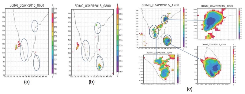
Spatial distributions of BT (K). (a) before convection, (b) initial stage of convection, (c) at peak of convection derived from INSAT-3D Imager satellite for 3rd April, 2015.
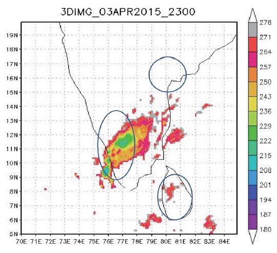
Spatial distributions of BT (K) after convection derived from INSAT-3D Imager satellite for 3rd April, 2015.
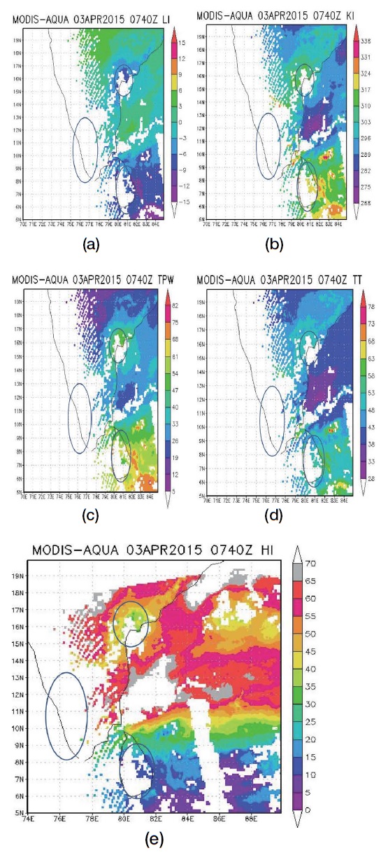
Spatial distributions of (a) LI, (b) KI, (c) TPW (mm), (d) TTI, (e) HI; all derived from MODIS-AQUA satellite for 21st April, 2015.
We tried to analyze the wind dynamics and the moisture associated with the convection using the help of Era-Interim ECMWF reanalysis satellite data. We plotted wind and total precipitable water vapor field at 6 hr time interval for the case study at 1000, 850 and 500 hpa, respectively. From the above figures (Fig. 4(a, b)), we have observed the TPW values are of the order of 40 to 60 mm are clearly seen across Kerala coast and also a southerly wind flowing across Guntur region is observed at 0000 UTC. At 0600 UTC, the southerly wind is just changing direction to easterly as observed near Guntur. At 1200 UTC, a moist air with high TPW values (50-55 mm) is feeding the Convective system at Kerala and Guntur. As the Anticyclone is blocking over Bay of Bengal, the humidity is channeled to Srilanka and Guntur. This system mainly forms over the region due to, “a north-south trough develops over the western parts of peninsula India due to excess heating of the land which is clearly seen.
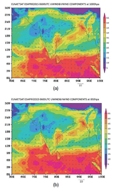
Era Interim ECMWF reanalysis satellite wind plots interpolated with total precipitable water at (a) 1000 hpa and (b) 850 hpa, respectively.
Specific Humidity, Relative Humidity, Vertical Velocity Profiles and Humidity Index were drawn at 0000, 0600, 1200 and 1800 GMT as shown in Fig. 5(a-g). From surface itself we can see the RH values are increased because of more availability of the moisture. Vertical Velocity profiles indicates that large negative values are observed at 0600 and 1200 GMT i.e. 6 to 8 hours before peak indicating an ascending motion/convection in the lower levels of the atmosphere. Large values of the vertical velocity on (when combined with high moisture level) indicate the potential for heavy rainfall (since pressure decreases with height, negative values indicate ascending air and the positive values denote sinking motion). Humidity index value at 1200 GMT drops suddenly from 21 to 10 which indicates very good conducive environment for convection activity. The T & Td profiles, tephigram (Fig. 5(a, d, g)) over Kerala, indicate the cold dry air is overlying on the warm moist air which is leading to convective instability causing to severe convection to occur. The height of LFC is 1.5 km where thunderstorm becomes more likely in super cells. Cape value is 2955.94 J/kg which indicate strong convective potential and CINE value is -6.56 J/kg, indicating weak inhibition.
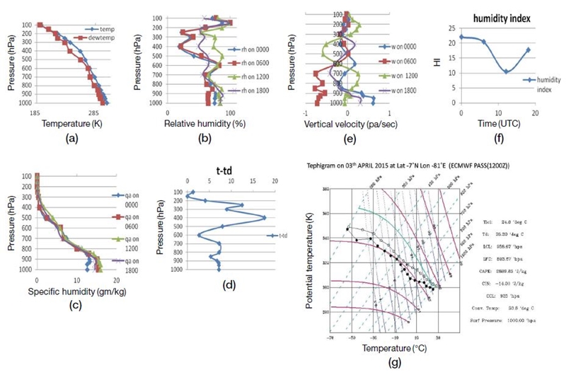
(a) Vertical profiles of T and Td interpolated at 100 hPa interval, (b) relative humidity, (c) specific humidity, (d) Dew point depression, (e) Vertical velocity, (f) Humidity Index, (g) Tephigram with T and Td; all derived from Era Interim ECMWF reanalysis satellite for 3rd April, 2015.
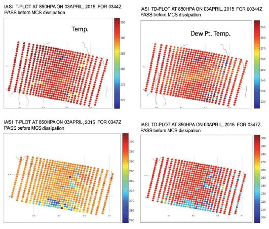
From Fig. 6 plots we can check the availability of data over the region of Convective system. Later, we have calculated HI, T, Td and Tephigram (Fig. 7(a-d)) at the region of occurrence. They explained the high probability for the occurrence of severe convection. The reason for using IASI satellite in our study was to analyze the convective system under cloudy condition. The T and Td data from advanced microwave sounder payload of IASI helps us to study the development of CS under adverse condition. The purpose of using IASI satellite is explained clearly in the case study 2.
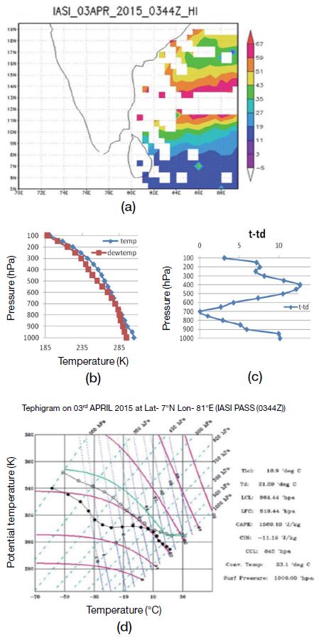
(a) Humidity Index, (b) Vertical profiles of T and Td interpolated at 100 hPa interval, (c) Dew point depression, (d) Tephigram with T and Td; all derived from IASI satellite for 3rd April, 2015.
The CAPE, LCL, CINE, LFC and CCL values calculated from MODIS Aqua, Era-Interim ECMWF reanalysis and IASI satellites (Table 1) clearly indicated very severe Convective system with thunderstorm. Our idea behind this type of analysis is to issue a severe convective system alert to the people. From the Table 1, we can observe that MODIS Aqua satellite and Era-Interim ECMWF reanalysis satellite were indicating good thresholds for the occurrence of severe convection.
3. 2 Case Study-2: 21st April, 2015
More than 44 people were dead and 100 others injured as a heavy storm with rain and hail swept through northern and north-eastern districts of Bihar State destroying standing crops and property worth several crores of rupees, as it was affected by an intense thunderstorm activity from 1730 to 2300 h IST of 21st April, 2015. The northern and north eastern parts of the Bihar state such as Purnea, Araria, Kishanganj, Katihar, Madhepura, Supaul, Saharsa, Bhagalpur, Samastipur, Darbhanga and Madhubani districts were affected severely (http://www.iffco.net/applications/meghdoot.nsf/1cf34024410130fd65256d3c001d3f04/4487ea8acf071d0365257e440020b029/$FILE/Purnea_thunderstorm_Report.pdf). On 21st April 2015, there was severe CS over west Bengal and Bihar regions. CS reached peak stage at 1300 UTC over west Bengal (Fig. 8(a)) and 1700 UTC over Bihar (Fig. 8(b)). They dissipated by 21 UTC. INSAT-3D BT values at peak time over West Bengal and Bihar are 190 K (-83°C) and 180 K (-93°C), respectively. MODIS Terra satellite data was available at 0420Z i.e. nearly 7 hours before the peak of Convective system and also at 0730Z MODIS Aqua pass was available i.e. nearly 4 hours before the peak of Convective system. By using this data, we were able to calculate the stability parameters for both the satellites TERRA and AQUA as shown in Fig. 9(a-d). The above values over West Bengal region indicate severe mesoscale convective system and a very high chance for severe rainfall and thunderstorm activity. The stability parameters calculated from MODIS terra & Aqua satellites indicated the occurrence of severe thunderstorm activity at the region of CS before 4 hours. The MODIS Terra & Aqua satellite passes were too early over the Bihar region. So, the Convective system was missing. The T and Td profiles, Tephigram (Fig. 10(a-c)) over West Bengal, indicate the cold dry air and warm moist air interacted in the lower levels of the atmosphere. CAPE, CIN, LFC, LCL indicated strong convection over West Bengal region.
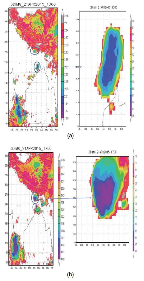
Spatial distributions of BT (K) at peak convection at (a) West-Bengal region, (b) Bihar region derived from INSAT-3D Imager satellite for 21st April, 2015.
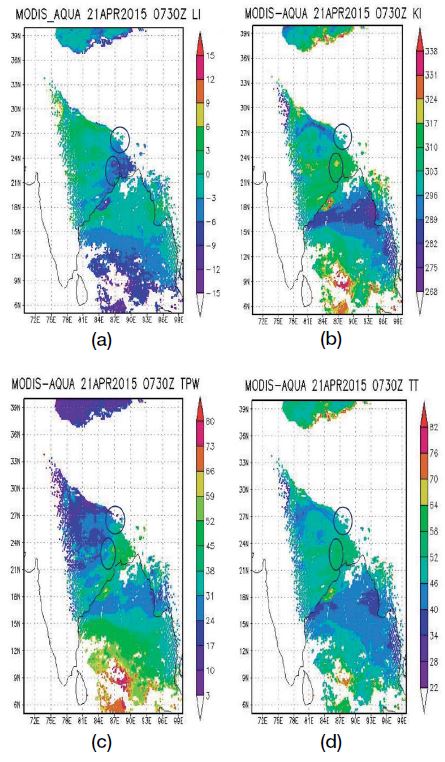
Spatial distributions of (a) LI, (b) KI, (c) TPW (mm), (d) TTI; all derived from MODIS-AQUA satellite for 21st April, 2015.
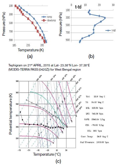
(a) Vertical profiles of T and Td interpolated at 100 hPa interval, (b) Dew point depression, (c) Tephigram with Tand Td; all derived from MODIS-TERRA satellite for 21st April, 2015.
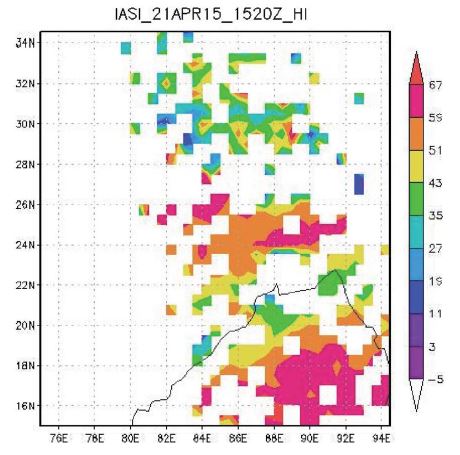
A low pressure region is observed in the Arabian sea and an upper air trough ran across Bihar, West Bengal and adjoining Nepal, extending up to 0.9 km above mean sea level is seen in 850 hPa plot at 1200 UTC (Fig. 11(a)). A strong westerly to north-westerly winds of the order of 40 knots (20.56 m/s) were blowing over Patna from 3 to 10 km above mean sea level is seen in the 500 hPa plot at 1200 UTC (Fig. 11(b)). This region is one of the prone areas for the experiencing Nor’westers during pre-monsoon season. A cyclonic circulation over Bihar and adjoining Sub-Himalayan West Bengal region was seen along with the moisture incursion from Bay of Bengal. The Convective system which was packed with high velocity winds and rain originates generally during evening or late night hours. Purnia recorded 20 mm of rain. The humidity Index (HI) calculated from IASI satellite clearly indicated the severity of Convective system just two hours before the occurrence (Fig. 12). The HI values reduced to 11 K at that time. When MODIS Terra and Aqua satellite passes were too early and were not helpful in predicting the convective system over Bihar region, IASI was very helpful in tracking it. The CAPE, LCL, CINE, LFC and CCL values calculated from MODIS Aqua, Era-Interim ECMWF reanalysis and IASI satellites (Table 2) clearly shows very severe Convective system. The HI parameter from IASI satellite helps us to alert the people in advance.
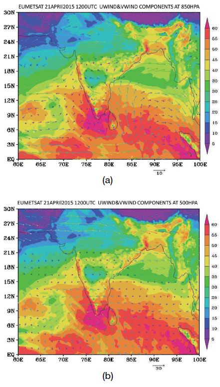
Era Interim ECMWF reanalysis satellite wind plots interpolated with total precipitable water at (a) 850 hpa & (b) 500 hpa, respectively.
4. CONCLUSIONS
In this present study, an attempt was made to analyze the data products of MODIS Terra & MODIS Aqua satellites, Era-Interim ECMWF reanalysis satellite and IASI satellite. The stability parameters were calculated by using these satellite datasets. These stability parameters were able to assess the occurrence of convective systems in advance. Seven convective systems were selected for April month during 2015. The brightness temperature plots from INSAT 3D satellite data were able to identify the stages of CS at every 30 minutes time interval. The threshold values of stability parameters which were calculated from different satellite datasets indicated the occurrence’s of various convective systems in advance.
(i) A clear drop in the brightness temperature values of convective systems was observed before 3 to 4 hours. At the peak stage of convective system, the BT values decreased till 190 K (i.e. -83°C). We tried to compute the atmospheric stability parameters (LI, KI, TPW, TTI and HI) for the CS dates over the convective regions (Table 4).
(ii) The parameters like Lifted Index (LI), k-Index (kI), Total totals Index (TtI), Humidity Index (HI) and total precipitable water (tpw) which was derived from MODIS Terra & Aqua satellites and Era interim ECMWF reanalysis satellite brought out the thresholds related to severe convection. The LI values were less than -5, kI values>320 K, TTI values>50 K, HI values<30 and TPW>45 mm are indicative of thunderstorm activity for the chosen cases.
(iii) When the MODIS Terra and Aqua satellite passes were too early before the initiation of convection, IASI satellite was found to be good alternative for studying the CS. In April 21st, 2015 case study; IASI was helpful in analyzing the severity of the convective system. IASI satellite was very reliable in predicting the convective system.
(iv) Very low LCL heights were observed from MODIS Terra and Aqua satellites over Kerala and Srilanka regions. From this we can understand that low surface point depressions favour the development of convective clouds.
(v) These systems started to develop in the late afternoon hours and reaches peak by late evening hours/night.
(vi) Typical profile of dew point depression was observed from MODIS Terra and Aqua satellites over some regions in which we have observed that the dew point depression is higher at the lower levels and equals zero at the middle two levels and again it increases i.e. a double helix profile of dew point depression as observed in some cases similar to Fig. 5(d). This may be strong heating of landmass during mid-day initiates convection over the region which moves southeast and gets intensified with mix up of warm moist air mass.
Acknowledgments
The authors express their gratitude towards SAC, ISRO, India for supplying INSAT-3D satellite data. We also thank NASA, USA for providing MODIS satellite data. We also thank ECMWF organization for supplying ERA daily data. This research work is funded by CSIRSRF project, sanctioned by Govt. of India under file No. 09/1068(0001)/2018-EMR-I.
ROLE OF THE FUNDING SOURCES
There are no funding sources for this article work.
CONFLICT OF INTEREST
The authors declare that there is no conflict of interest regarding the publication of this paper.
References
-
Brandes, E.A. (1990) Evolution and structure of the 6-7 May 1985 mesoscale convective system and associated vortex. Monthly Weather Review, 118(1), 109-197.
[https://doi.org/10.1175/1520-0493(1990)118<0109:EASOTM>2.0.CO;2]

-
Brooks, H. (1994) On the environments of tornadic and non tornadic mesocyclones. Weather and Forecasting, 9(4), 606-618.
[https://doi.org/10.1175/1520-0434(1994)009<0606:OTEOTA>2.0.CO;2]

-
Daidzic, N.E. (2019) A new model for lifting condensation levels estimation. International Journal of Aviation, Aeronautics, and Aerospace, 6(5).
[https://doi.org/10.15394/ijaaa.2019.1341]

-
Feng, Z., Leung, L.R., Houze Jr., R.A., Hagos, S., Hardin, J., Yang, Q., Han, B., Fan, J. (2018) Structure and evolution of mesoscale convective systems: Sensitivity to cloud microphysics in convection-permitting simulations over the United States. Journal of Advances in Modeling Earth Systems, 10(7), 1470-1494.
[https://doi.org/10.1029/2018MS001305]

-
Galway, J.G. (1956) The Lifted Index as a Predictor of Latent Instability. Bulletin of the American Meteorological Society, 37(10), 528-529.
[https://doi.org/10.1175/1520-0477-37.10.528]

- George, J.G. (1960) Weather Forecasting for Aeronautics. Academic Press, p. 673.
-
Guevara Luna, M.A., Guevara Luna, F.A., Méndez Espinosa, J.F., Belalcázar Cerón, L.C. (2018) Spatial and temporal assessment of particulate matter using AOD data from MODIS and surface measurements in the ambient air of Colombia. Asian Journal of Atmospheric Environment, 12(2), 165-177.
[https://doi.org/10.5572/ajae.2018.12.2.165]

-
Hilgendorf, R.E., Johnson, H.R. (1985) A Study of the evolution of mesoscale convective systems using WSR-88D data. Weather and Forecasting, 13(2), 437-452.
[https://doi.org/10.1175/1520-0434(1998)013<0437:ASOTEO>2.0.CO;2]

- Houze Jr., R.A. (1993) Cloud Dynamics. Academic Press, p. 573.
-
Jayakrishnan, R.P., Babu, A.C. (2014) Assessment of convective activity using stability indices as inferred from radiosonde and MODIS data. Atmospheric and Climate Sciences, 4(1), 122-130.
[https://doi.org/10.4236/acs.2014.41014]

-
Johns, R.H., Doswell III, C.A. (1992) Severe local storms forecasting. Weather and Forecasting, 7(4), 588-612.
[https://doi.org/10.1175/1520-0434(1992)007<0588:SLSF>2.0.CO;2]

- Karmakar, S., Alam, M. (2006) Instability of the troposphere associated with thunderstorms/nor’westers over Bangladesh during the pre-monsoon season. Mausam, 57(4), 629-638.
-
Knupp, K.R., Cotton, W.R. (1987) Internal structure of a small mesoscale convective system. Monthly Weather Review, 115(3), 629-645.
[https://doi.org/10.1175/1520-0493(1987)115<0629:ISOASM>2.0.CO;2]

-
Kober, K., Tafferner, A. (2009) Tracking and nowcasting of convective cells using remote sensing data from radar and satellite. Meteorologische Zeitschrift, 18(1), 75-84.
[https://doi.org/10.1127/0941-2948/2009/359]

- Koteswaram, P., Srinivasan, V. (1958) Thunderstorms over Gangetic West Bengal in the pre-monsoon season and the synoptic factors favourable for their formation. Indian Journal of Meteology and Geophysics, 9(4), 301-312.
- Litynska, Z., Parfiniewicz, J., Pinkowski, H. (1976) The prediction of air mass thunderstorms and hails. World Meteorological Organization, 450, 128-130.
- Miller, R.C. (1967) Notes on analysis and severe storm forecasting procedures of the Military Weather Warning Center. Technical Report 200.
-
Moncrieff, M., Miller, M. (1976) The dynamics and simulation of tropical cumulonimbus and squall lines. Quarterly Journal of the Royal Meteorological Society, 102(432), 373-394.
[https://doi.org/10.1002/qj.49710243208]

- Mukhopadhyay, P., Sanjay, J., Singh, S.S. (2003) Objective forecast of thundery/non-thundery days using conventional indices over three northeast Indian stations. Mausam, 54(4), 867-880.
-
Madhulatha, A., Rajeevan, M., VenkatRatnam, M., Bhate, J., Naidu, C.V. (2013) Now casting severe convective activity over southeast India using ground-based microwave radiometer observations. Journal of Geophysical Research: Atmospheres, 118(1), 1-13.
[https://doi.org/10.1029/2012JD018174]

-
Park, S.Y., Lee, H.W., Lee, S.H., Kim, D.H. (2010) Impact of wind profiler data assimilation on wind field assessment over coastal areas. Asian Journal of Atmospheric Environment, 4(3), 198-210.
[https://doi.org/10.5572/ajae.2010.4.3.198]

-
Parker, D.J. (2002) The response of CAPE and CIN to tropospheric thermal variations. Royal Meteorological Society, 128(579), 119-130.
[https://doi.org/10.1256/00359000260498815]

-
Rädler, A.T., Groenemeijer, P.H., Faust, E., Sausen, R., Púčik, T. (2019) Frequency of severe thunderstorms across Europe expected to increase in the 21st century due to rising instability, npj Climate and Atmospheric Science, 2, 30.
[https://doi.org/10.1038/s41612-019-0083-7]

-
Rajeevan, M., Kesarkar, A., Thampi, S.B., Rao, T.N, Radhakrishna, B., Rajasekhar, M. (2010) Sensitivity of WRF cloud microphysics to simulations of a severe thunderstorm event over southeast India. Annales Geophysicae, 28, 603-619.
[https://doi.org/10.5194/angeo-28-603-2010]

- Rao, K.N., Raman, P.K. (1961) Frequency of days of thunder in India. Indian Journal of Meteorology and Geophysics, 1, 103-108.
-
Rycroft, M.J. (2014) Thunder and lightning - what determines where and when thunderstorms occur?. Environmental Research Letters, 9(12), 121001.
[https://doi.org/10.1088/1748-9326/9/12/121001]

-
Schultz, P. (1989) Relationships of several stability indices to convective weather events in northeast Colorado. Weather and Forecasting, 4(1), 73-80.
[https://doi.org/10.1175/1520-0434(1989)004<0073:ROSSIT>2.0.CO;2]

-
Smull, B.F., Houze Jr., R.A. (1985) A midlatitude squall line with a trailing region of stratiform rain: Radar and satellite observations. Monthly Weather Review, 113, 117-133.
[https://doi.org/10.1175/1520-0493(1985)113<0117:AMSLWA>2.0.CO;2]

-
Tao, W.K., Chern, J.D. (2017) The impact of simulated mesoscale convective systems on global precipitation: A multiscale modeling study. Journal of Advances in Modeling Earth Systems, 9, 790-809.
[https://doi.org/10.1002/2016MS000836]

- Tyagi, A. (2007) Thunderstorm Climatology over Indian Region. Mausam, 58(2), 189-212.
- Yashvant, D. (2015) Some Aspects of thunderstorm over India during pre-monsoon season: A preliminary report-I. Journal of Geosciences and Geomatics, 3(3), 68-78.
-
Zipser, E.J. (1977) Mesoscale and convective-scale downdrafts as distinct components of squall-line circulation. Monthly Weather Review, 105, 1568-1589.
[https://doi.org/10.1175/1520-0493(1977)105<1568:MACDAD>2.0.CO;2]

